|
Some information about Aqsu and Hoten
Aqsu
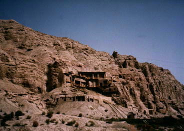
Aksu city (1994 est. pop. 193,700), SW Uyghur Region , on the Aksu River. The center of an oasis at the foot of the Tengri Tagh mts., it is a caravan hub on the Old Silk Road. Industries include textile and carpet manufacturing, jade carving, tanning, and metal working. Iron deposits are in the area. Aksu has ancient Buddhist statues
and caves, but most are in poor condition. The name sometimes appears as Aqsu.
Hoten/Khotan
Khotan , city and oasis ,SW Uyghur Region, near the headstream of the Hotan River. It is the center of an area growing cotton, corn, wheat, rice, and fruit. Silk and cotton textiles and carpets are manufactured, and jewelry is made from the great quantity of jade in the area. On the southern part of the Silk Road, Hotan was an early center for the spread of Buddhism from India into China, and grew wealthy on the proceeds of the caravan trade that traveled the route between East and the West. Its prosperity ended with the conquest of Hotan by Jenghiz Khan. Hotan is connected by road with Kashi (Kashgar) and Urumchi. The name sometimes appears as Hoten
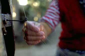
Some of the crafts most often associated with Htan is that of carpet- making, Jade carving and Silk Making. The more plentiful nephrite, a silicate of calcium and magnesium(usually with some iron), is the jade from Hotan. Colors Nephritic jade was originally found in the form of pebbles from alluvial deposits in Uyghur Region and was first mined from rock in the 12th century.
Khotan forms a city and is the administrative centre of the Hoten (Khotan) prefecture which administers a string of counties based on the oases along the southern edge of the Takla Makan Desert.
The oasis of Hoten , the largest of these, includes Qara Qash , to the northwest, and Lop, to the east. The oasis is watered by the Qara Qash River and Yorung-kash River, which flow from the high qara Qorum Mountains to the south. They join in the north of the oasis to form the Hoten (Khotan) River, which discharges into the desert to the north. The rivers have their maximum flow during summer and are almost dry for much of the year.
The oasis is a long-established centre of carefully irrigated cultivation. Corn (maize), wheat, rice, and millet are the staple grains. Cotton is intensively grown, and the area produces much fruit, including mulberries. It has a well-established textile industry, producing silks and cotton fabrics. Local herds produce fine wool that is used for making carpets and felt goods. The area is a source for a limited amount of alluvial gold and is famous throughout the Far East as the major source of jade. It is also famous for its metalwork and jewelry.
Location: located at the northern foot of the Karakorgan Range and on the southern fringe of the Taxkorgan Desert with an elevation of 1,372 meters
Neighboring areas: Gansu province , Qinghai province and, Tibet Autonomous Region
Physical Features: slopes down from south to north with Karakorgan Mountains to the south and Taxkorgan Desert to the north
Area: 247,800 sq km
Climatic Features: located in the warm temperature zone, dominated by a dry continental desert climate; hot in summer and not too cold in winter; great temperature disparity between day and night with little rainfall and a high evaporation rate; frost-free of 182 and 226 days a year; an average sunshine time of 2470.4 to 2875.9 hours annually
Average Temperature: 11-12.1°C
Rainfall: annual rainfall of 28.9 to 47.1 mm
Mountains: Karakorgan Range, Qara Qorum
Rivers: Qarakax River, Yurongqax River, Hoten River, Aksu River, Yarkant River, and etc
Local Highlights: Hoten jade, Hoten sheep, Hoten silk, Hoten carpet
|
 Located on west bank of the Yorung Qash River, 25 kilometers west in Hotan city, the old city is the capital of ancient Kiriye kingdom, which declined in the period between the year 206 BC and the year 907 AD. The city is 400 meters long from south to north, 745 meters wide at the south and 450 meters wide at north. In the ruins, there are many high earthen mounds and several hundred housing column bases. There are also many red and grey potsherds, fragments of pottery statues of Buddha and coins.
The capital of Kiriye state was an important frontier town in its time, and also a strategic
Yotqan Ancent City
According to record, the ancient city of Yotkan, which buried 4 meters under earth 10 km west of present-day Hotan , was the capital of Kingdom of Hotan of 3-8 century AD. It was said that the city once covered an area of 10 square kilometers. Many relics were found here, which include pottery, animal bone, gold ornaments, jade articles, etc. The pottery found here depicted animals and figures in a style heavily influenced by Indo-Hellenistic and Persian styles. The gold found here often take the shape of thin leaf, which could prove that some of the buildings must be lavishly with gold. People also found some coins from the Tang dynasty here
Ancient City Of Niya
Lies in 130 kilometers north the Niye county, the site, 10 kilometers from south to north and 2 kilometers from west to east, is scattered with many houses' ruins. Archaeologists unearthed many precious wooden slips and tablets, Kharosti and the ancient Kiriye as well as coins, wooden tools, silk, linen, wheat, barley, broom corn millet, mutton, sheep hooves and gourds. There are grave region which is 2 kilometers north of the houses' ruins, in which most of the coffins were cut out of single log
|