|
|
|
| Urumchi-Qaramay | |
|
Uyghur Photo Site |
Site Manager |
Contact Page |
Information |
In the World |
Kashgar-Atush |
Turpan |
Urumchi-Qaramay |
Qumul-Korla |
Hoten-Aksu |
Ili-Altay |
Kucha |
People |
Culture |
Nature |
Favorite Links |
Uyghur Photo Guest Book
|
|
|
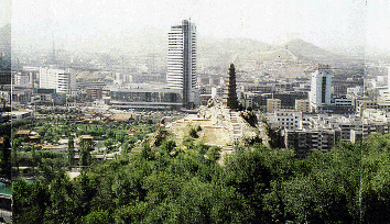
Here are some information about of Urumchi and Qaramay
|
|
 |
Urumchi Coming Soon |
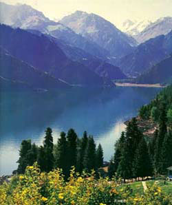 |
Heaven Lake
Heaven Lake is 110km (68 miles) east of Urumqi and a car ride from the capital will take around 3 hours. The lake is 2,000 meters (6,500ft) above sea level on the stunning Boghda mountain. This large pristine lake is surrounded by alpine meadows and snow-capped mountains. The steep Heavenly Mountains (tianshan) are densely packed with pine and cypress trees as well as fields of wild flowers and herbs. Visitors will be struck by the grandness of the natural environment and to truly enjoy the splendor of the lake, should plan on staying overnight. Many visitors choose to stay in a traditional Kazakh yurt, which is an unforgettable cultural experience. Once the tour buses have left in the late afternoon the lake is peaceful and magical. Tourists can go for strolls on the mountain paths and the more athletic can hike or ride a horse up to the glacier plains where the scenery is simply stunning. |
 |
Red Hil Red Hill, 1.5 kilometers long and one kilometer wide and 910 meters above sea level, is situated on the east side of the Urumqi River and at the very center of the city, running from east to west. The hill top looks like a mighty lion in its quiet sleep and the ridge like a wriggling dragon. The hill's rocks are reddish-brown, hence the name "Red Hill". At the top of the hill stands a nine-story, solid, gray brick pagoda 8 meters high, facing one at the top of the Yamalik Hill. According to historical documents, the Urumqi River at the foot of the Red Hill overflowed in 1785 and the year after. Some superstitious people at that time rumored that it was the evil done by a vicious dragon and that the Red Hill and the Yamalike Hill would join to each other blocking up the river and Urumqi area would turn into a vast expanse of water the Splendid temples attracted a great number of visitors and made the hill a holy place where worshippers chanted the Buddhist sutra and conducted religious services. Unfortunately almost all these |
 |
South Mountain
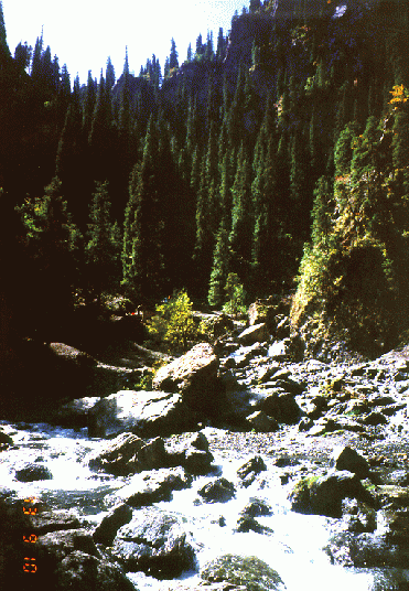
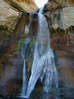
The "Southern Mountains" generally refers to the mountain area at the northern foot of Karawuquntag Mountain, a branch of the Tangri Tagh Mountains to the south of Urumqi. This place is not only an excellent natural pastureland but also an ideal summer resort for sightseeing visitors. There are dozens of parallel valleys and ravines running from west, with the West Poplar Valley as the most famous one. Seventy-five kilometers south of Urumqi, the West Poplar Valley is located in the transition zone between low mountains and the mountains of intermediate height. At an elevation of 2,100 meters, it has an annual rainfall of 500 to 600 millimeters. The valley, screened by snow-capped peaks and dotted with tall and straight dragon spruce trees, is covered with a carpet of green grass. Setting off the deep shade of the green trees are white yurts scattered here and there, and small exquisite villas, elegant and quiet sanatoriums, reception houses for foreign guests and snack bars make the valley even more attractive. When making an excursion into this place, visitors are welcomed as guests to the yurts of the local Kazak herdsmen and always offered fragrant milk tea, mare's milk, cheese and delicious roast lamb. They can entertain themselves to their hearts' content with singing and dancing in threes and fours and ascend the heights, threading their ways through the deep woods, to enjoy the picturesque landscape. Young visitors who are found of horsemanship can hire fine horses for a few coins from the local Kazak herdsmen, and make use of the whip to urge on the horse to gallop across the vast pastureland. At the far end of the valley, one finds the landscape even more spectacular. From a striking precipice hiding in the green trees, a waterfall two meters wide cascades forty meters, floating down like a white silk in the air, roaring down to the bottom and spraying fine water droplets and mist onto the rocks covered with mosses and the green leaves on both sides, just like a drizzle making people feel pleasantly cool. |
|
|
 |
|
|
|
|